The Impact of Drone in the Land Surveying Industry in India
Technology drives improvements in working practices in all sectors and the land surveying industry are no stranger to this type of advancement. It is an industry that has embraced new technology for many years in an attempt to improve accuracy and efficiency in infrastructure development. The rapid development of drones has seen a significant rise in their use for land surveying in India and given surveyors the ability to provide more accurate and efficient service for clients in sectors such as urban planning, mining, agriculture, irrigation, energy, and many more.
A breakthrough in land surveying
Land surveying is a crucial aspect of planning and development. Understanding the layout and structure of the area to be developed is essential in order to plan appropriately. The more knowledge of the area you have, the more accurate your planning decisions will be and the more chance you have of ensuring your project is completed on time and on budget.
India is vastly populated and its towns and cities are dense, complex areas that do not lend themselves to traditional surveying techniques. With so many people living and working in these areas, trying to obtain accurate survey data can be tricky, expensive, and time-consuming. Aerial surveillance provides an opportunity to obtain large amounts of accurate data in a short period of time and with fewer human resources required. These images give planners a chance to examine existing social and environmental conditions and consider the impact of several different planning scenarios.
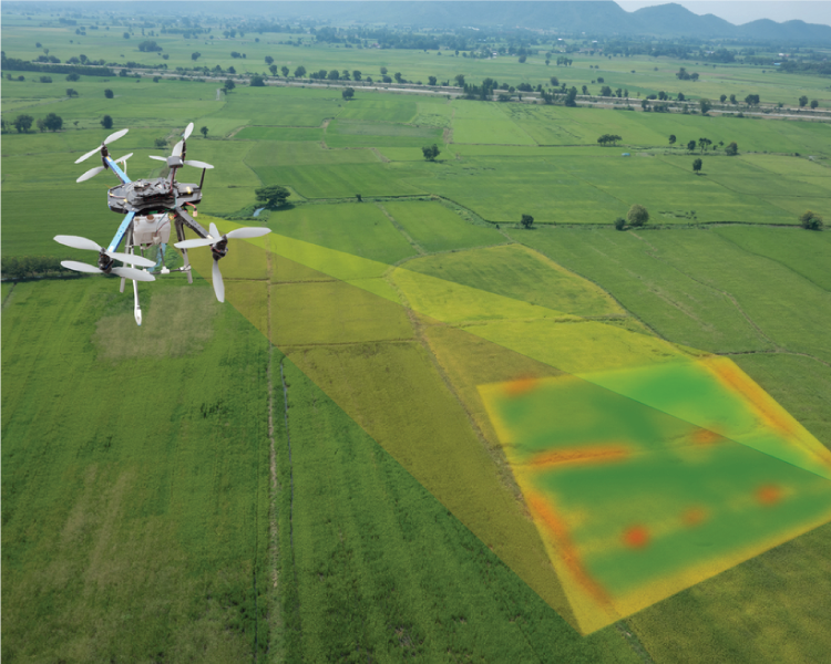
Drone surveying involves flying the drone above the area to capture images from several different angles. A single survey can result in thousands of images, each tagged with coordinates before being fed into a photogrammetry software program. Here, the data is georeferenced to create accurate 2D and 3D representations of the surveyed area, which can be used to extract precision distances and volumetric measurements.
It can also be transferred to CAD software to create a 3D model, giving planners a tangible asset which they can use to examine the relationships between different aspects of the area when planning their project. This 3D model can also be produced for the engineers to work from. Due to the low cost of drone surveys and the vast capacity for storing digital images, further surveys can be carried out as the project develops. These can be overlaid onto the original blueprints to monitor and assess the construction work continually.
Increase in demand for drones
During the last five years, India has seen a huge increase in the demand for surveying drones as land surveyors have realized their potential. Drones are relatively inexpensive and can be a cost-effective method of surveying land compared with more traditional techniques. They are also easy to transport and can be taken anywhere – even to remote places which were once seen as, if not impossible to survey, certainly a major logistical challenge. Moving cumbersome equipment in hazardous conditions is a dangerous and expensive activity. Other benefits include the lack of disruption, such as closing roads or railways.
Surveying from the sky, drones use georeferenced imagery to provide incredibly accurate mapping safely, negating terrain as an obstacle. Drones provide absolute precision via aerial photography and accurate 3D reviews. These can be used by surveyors and developers to obtain detailed knowledge of an area without leaving their office – saving time and money while making the whole project more slick and efficient. But there is a further development in the offing, and not just in regards to the drones themselves. Innovations in positioning technology, image processing algorithms, and compact high-capacity imaging sensors are rapidly improving the way surveying data is used. The drone themselves are just one small but significant part of the overall advancement in land surveying in India.
Precise measurements even in hard to reach places
But it is not just in the sky that drones have proven their worth in safe surveying. In recent years, mining companies across India have come to realize the benefits of a drone in surveying too. Surveying mines can be a hazardous task, and one that is essential to get right as the planning, development, and construction of the mine will be led by the data captured during the survey. Sending drones down mines is much faster, much safer, more cost-effective, and less labor-intensive than sending people down to do the job. And, as mentioned above, the data is far more accurate than ever before, and the way in which it is used far more complex.
Volumetric measurements are of huge significance when mapping a mine as it provides data for stocks and inventory management. Due to the huge number of images obtained during a drone survey, those volumetric measurements are more accurate than it would be practically possible to gain from a manual survey. And they take a fraction of the time to collate. The quality of images provided by a drone is around 10 times better than traditional methods – and as the market for drones in surveying continues to grow, we can expect to see the images become even greater quality. Indeed all technology associated with drones is likely to improve in terms of speed, precision, and the way in which data is used to lower costs and improve efficiency.
Prevention is better than cure
Planning to deal with future problems and putting in preventative measures is a major benefit of the speed at which drone surveys can be carried out. So, across the globe, the future of disaster prevention relies heavily on drone surveys.
Drone imagery can provide precise measurements for slopes and determine where the terrain is shifting due to its gradient, and at what rate. This is vital information in the prevention of landslides and can also be used to help authorities identify areas at risk of flooding or other natural disasters. The data supplied by drones arrive much faster and is far more accurate than traditional methods which involved placing sensors on specific points to monitor the shift. With drones, one can take far more measurements from different angles to provide a fuller picture of the issues and thus make better decisions on the preventative measures required. Given the potentially hazardous nature of these types of sites, drones are also safer for surveyors as they don’t require a person to enter the area. They are also far less likely to disturb the land which would actually increase the risk.
Orthomosaic images taken at various times and overlaid on top of one another can detect structural changes such as the movement of the earth, which could lead to earthquakes or damage to highways and other areas of land. By regularly monitoring a site and obtaining this type of information promptly, steps can be taken to mitigate those risks, ensuring life goes on as normal while saving money, and potentially lives, into the bargain.
Speed is of the essence
One of the key benefits of drones, apart from their ability to reach remote locations, is the speed at which they work. A 100-hectare site surveyed by conventional methods would require several man-hours, but a drone will carry out the same survey in around 30 minutes to 2 hours depending on the complexity of the area being surveyed.
The speed at which the drone is able to work in surveying was seen to good effect in Maharashtra, India 2019. With water levels in the region falling rapidly over a number of years, local authorities recognized the need to rethink the irrigation of the land and find solutions to ensure the 1085 villages that faced water shortages could be saved from the loss of this basic necessity. Using drones to conduct aerial surveys, a massive 120 sq km of area per day was surveyed over a period of two months. The images obtained were used to map out a plan to safeguard the water in tail-end agricultural fields to solve the problem. This is just one example of how drones have formed a crucial part of a pro-active problem-solving approach in India.
Mapping India
The benefits of drone surveys in India are not lost on the central government either. A Survey of India has been drafted by authorities to digitally map every area of the country in a project that promises to revolutionize the nation. In 2019 a joint project between Survey of India and the Karnataka Revenue Department used images captured by drones to create digital surveying maps and ownership records across Jayanagar. The success of the pilot scheme has prompted further drone surveys in Karnataka and in other areas of the country too. India is leading the way with this survey as nowhere else in the world has attempted a drone survey of this size and scale.
Survey of India has announced plans to increase its fleet of drones from 30 to 300 to complete the task which will produce a fully digitized map of the entire country. This information will enable local and national governments to make more informed decisions for the betterment of the people on such matters as land use planning, travel networks, and water resources. It will also assist the courts in settling land disputes.
By the end of 2020, 4000 property owners in Jayanagar should receive a digitized georeferenced draft property ownership card based on the images captured via drone surveys. With over 2.5 million hectares of land in India currently subject to ownership disputes and 25% of them likely to end up in the Supreme Court, it’s easy to see how this project could free up the court’s time to deal with other matters and save both the authorities and landowners a small fortune in legal costs.
In India, Drone has massively changed the landscape for land surveyors and look set to be a key part of surveying and planning for urban and rural areas for years to come. Never before has such accurate data been so readily available to surveyors, and never before have planners, developers and engineers had access to this quality of data at the speed and cost that it can now be offered. Across India, the value of aerial surveying carried out remotely by drone operators is increasingly being recognized and there can be no doubt that the benefits to individuals, companies, authorities, and the nation as a whole are multi-faceted and will help to improve and develop the infrastructure for the wellbeing of all.