Building on Hilly Terrain: A Surveyor’s Guide to Smart Construction
When it comes to building on hilly terrain, most people—architects included—often overlook the first and most critical step: comprehensive land and geotechnical surveying. While sloped land offers incredible design potential and natural beauty, it also poses serious structural, environmental, and legal risks. And the best way to avoid costly mistakes? Start with accurate data from the ground up—literally.
This blog dives deep into the must-know facts, strategies, and survey insights you need to plan and construct safely on slopes. Whether you’re an architect looking to design a hillside home or a property owner eyeing a sloped site, this guide is your foundation for smarter, safer construction.
1. Why Hilly Terrain Is Different
Sloped sites aren’t just uneven land—they’re dynamic landscapes that demand strategic planning. What makes them unique?
- Irregular Topography: No two hills are the same. Contours vary widely even within the same property.
- Erosion & Drainage Risks: Gravity increases water runoff, which can wash away soil and destabilize foundations.
- Complex Access: Transporting materials and machinery is more difficult and costly on steep slopes.
- Regulatory Hurdles: Local building codes for hillsides are often stricter, demanding slope analysis, setbacks, and erosion control measures.
Without proper land and geotechnical surveys, even the most elegant design can become a money pit—or worse, a hazard.
2. The Role of Land Surveying in Hillside Construction
Topographic Surveys
Slopes aren’t just angles—they’re forces. Without a topographic survey, you’re designing blind.
Topographic surveys surveys map the elevation and contours of your land. They reveal:
- Natural slopes and inclines
- Drainage paths and low points
- Rock outcrops, trees, and boulders
- Areas suitable for excavation, terracing, or stilts
This is the survey that allows your architect to create a design that works with the land, not against it.
Check out our most Popular post: Everything you need to know about Topographic Surveys
Boundary Surveys
Sloped lands can deceive the eye. Boundaries aren’t always as obvious as they seem, and misjudgments can lead to legal disputes or violations. Boundary surveys clarify:
- Property limits
- Easements
- Encroachments
- Road access
A must for planning accurate setbacks and ensuring code compliance.
Check out our popular post that architects love: How Does an Acre Measure on Hills?
3. Why Geotechnical Surveying Is Critical
Land is only as strong as what’s beneath it. Only a geotechnical survey can determine if the soil can support your foundation. Is it clay, loam, or rocky fill? Will it hold up during monsoons or tremors? The wrong assumptions here can lead to landslides, cracks, or total failure.
These surveys test:
- Soil type and bearing capacity
- Rock depth and layering
- Groundwater levels
- Landslide or erosion risk
With these insights, engineers can recommend foundation types like:
- Stepped Footings
- Raft or Mat Foundations
- Pile Foundations
- Retaining Wall Systems
Without this, your building could literally sink, slide, or crack over time.
Hillsides demand smart stormwater planning. Surveying identifies natural water paths, preventing future basement floods or slope erosion. Combine this with retaining walls and you’ve got long-term resilience.
4. Smart Building Design Starts with Survey Data
With accurate terrain models, architects can unlock designs and explore construction methods that fit your specific slope options like:
Cut and Fill
Level the building platform by cutting into the high side and using that material to fill the lower side. Works best on moderate slopes, but requires erosion control and compacted fill.
Stepped Design
Divide the building into levels that follow the natural slope. Great for residential projects—offers better views and daylighting.
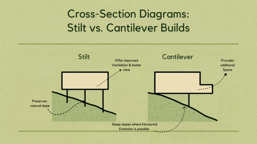
Stilt Construction
Elevate the building above the ground using columns. Ideal for steep or flood-prone slopes, preserves natural contours and vegetation.
Cantilevering
Let the structure overhang the slope, anchored to a strong foundation. Popular in luxury and modern architecture, but requires precise structural engineering.
Basement Integration
Embed part of the structure into the hill as a basement. Stabilizes the slope and provides cool, usable space.
Each method depends on site-specific survey data. What works on one slope might fail spectacularly on another.
You can explore more construction methods like stilt and cantilever design in this related blog: Construction Strategies for Sloped Sites
5. Regulatory Compliance: What the Codes Say
Building codes for hilly terrain aren’t just red tape—they’re safety systems. Some key standards include:
- Minimum 1.5m gap between retaining wall and main structure
- Maximum cutting height of 4m for stepped buildings
- Prohibition of hill face as structural wall (unless rock-stable)
- Required setbacks from edges, roads, and drainage lines
- Restrictions on placing wet areas (kitchen, toilets) against the hill due to seepage risk
Land and geotechnical surveys provide the documentation needed for permits and planning approval.
Need hassle-free DTCP building approvals in Tamilnadu? Contact Propdoc they offer a complete solution for all Building Regulatory Compliances.
6. Common Mistakes When Building on Hills
- Skipping surveys: Results in poor drainage, structural failures, or legal issues
- Overcutting: Causes slope destabilization and increased erosion
- Ignoring water flow: Leads to basement flooding or foundation weakening
- Flat-land design on a slope: Increases cost, complexity, and long-term risk
- Undervaluing access planning: Causes logistical nightmares during construction
Avoid these by grounding your design in solid data—survey first, build later.
7. Real-World Application: How Surveying Saved a Hillside Project
In a recent hillside villa project, the architect approached us after realizing the terrain had unexpected challenges. Our land and geotechnical surveys revealed:
- Hidden bedrock at shallow depth (cut and fill wasn’t viable)
- Seasonal water runoff paths that could flood the basement
- Soil type prone to erosion
Based on this, the design was modified to a stilt + stepped hybrid with proper drainage channels and retaining walls. The result? A safer, more cost-efficient structure that stayed in harmony with nature—and avoided six-figure repair risks.
One of our clients, an architect building a tiered eco-retreat in the Western Ghats, used our combined land and geotechnical surveying services. The site had deceptive gentle slopes that concealed high water runoff risk. Thanks to early intervention, we helped redesign their foundation and avoid costly post-construction drainage fixes.
Read this related blog how to design building on a hilly terrain or sloppy terrain?
8. Surveying Is Not a Cost—It’s an Investment
Some clients hesitate to spend on land or geotechnical surveys. But skipping this step often leads to:
- Foundation redesigns
- Drainage failures
- Building code violations
- Delays and fines
Compare that to the upfront cost of surveying, and it’s clear: Surveys are your insurance against disaster.
9. Key Survey Insights Needed for Hillside Construction
| Survey Type | What It Reveals | Why It Matters |
| Topographic | Slope angles, contours, features | Guides layout, earthwork, drainage |
| Geotechnical | Soil type, rock depth, water table, stability | Determines foundation type & risk factors |
| Boundary | Legal plot lines and setback areas | Avoids disputes and ensures compliance |
Conclusion: Build Smart, Build Secure on Hilly Ground
Constructing on hilly terrain is not just about overcoming gravity—it’s about understanding the land before shaping it. The beauty and potential of a sloped site come with hidden challenges, and it’s the precision of land and geotechnical surveying that transforms those challenges into informed design opportunities.
A professional surveyor doesn’t just measure land—they reveal its story. From contours and boundaries to soil strength and drainage paths, these insights form the critical groundwork for safe, resilient, and efficient hillside development.
Before your blueprint becomes a building, make sure your foundation is built on knowledge. Partnering with expert surveyors ensures that your project respects the land, complies with local regulations, and thrives for decades to come.
In hilly terrain, smart planning isn’t a luxury—it’s a necessity. And every great structure begins with the right data. Let your next project rise from solid, surveyed ground—confident, compliant, and crafted to last.