
Introduction
Have you ever wondered how architects can create intricate and precise designs for complex structures? The secret lies in the accurate land data provided by various types of land surveys and advanced technologies. Understanding these surveys and technologies is crucial for architects, as they form the bedrock of successful project planning and execution. By mastering this knowledge, you can enhance your architectural projects’ precision, efficiency, and sustainability.
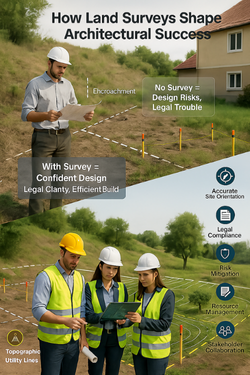
1. Importance of Land Surveys in Architecture
Land surveys are a foundational element in the architectural process, playing a crucial role in the successful planning, design, and execution of construction projects. Here’s a detailed exploration of why land surveys are indispensable for architects:
a. Foundation of Design
Accurate Site Assessment: Land surveys provide a comprehensive assessment of the site, offering detailed information about the land’s dimensions, contours, and existing features. This data is essential for creating accurate and feasible designs that fit the site’s specific characteristics.
Informed Decision-Making: With precise land data, architects can make informed decisions about the placement and orientation of structures, ensuring they are optimally positioned to take advantage of natural light, views, and other environmental factors.
Customization and Innovation: Understanding the exact layout and features of a site allows architects to customize their designs to enhance functionality and aesthetics. This leads to innovative architectural solutions that are both practical and visually appealing.
b. Legal Compliance
Boundary Identification: Boundary surveys clearly define property lines and identify any encroachments or easements. This information is crucial for ensuring that the proposed structures are within the legal boundaries of the property, preventing future legal disputes.
Zoning and Building Codes: Surveys provide essential data needed to comply with local zoning laws and building codes. This includes setbacks, height restrictions, and land use regulations, which vary from one jurisdiction to another.
Permit Acquisition: Accurate land surveys are often required to obtain necessary permits and approvals from local authorities. They provide the documentation needed to demonstrate that the project meets all regulatory requirements.
For more details, feel free to contact Prime Propdoc Consultants Private Limited
c. Risk Mitigation
Identifying Potential Issues: Land surveys help identify potential issues that could affect the project, such as flood zones, soil instability, and existing underground utilities. By detecting these issues early, architects can develop strategies to mitigate risks and avoid costly problems during construction.
Environmental Considerations: Surveys can reveal environmental features such as wetlands, protected areas, and significant vegetation. This information is crucial for ensuring that the project complies with environmental regulations and minimizes its impact on the natural surroundings.
Property Disputes: Clear and accurate boundary surveys can prevent property disputes with neighbors, ensuring that all parties agree on the exact property lines and reducing the likelihood of legal conflicts.
d. Resource Management
Efficient Space Utilization: Detailed topographic and boundary surveys provide the information needed to make efficient use of available space. This is particularly important in urban areas where land is limited and expensive.
Material Planning: Accurate land data allows architects to plan the precise quantity and placement of materials needed for construction. This reduces waste and ensures that resources are used efficiently, leading to cost savings and more sustainable building practices.
Infrastructure Planning: Surveys provide essential data for planning infrastructure elements such as roads, utilities, and drainage systems. This ensures that these elements are integrated seamlessly into the overall design, enhancing the functionality and sustainability of the project.
e. Enhancing Project Communication
Stakeholder Collaboration: Land surveys provide a common reference point for all stakeholders involved in a project, including architects, engineers, contractors, and clients. This enhances communication and collaboration, ensuring that everyone is working from the same accurate data.
Visualization and Planning: Surveys can be used to create detailed maps, models, and visualizations of the site. These tools help stakeholders understand the project’s scope and scale, facilitating better planning and decision-making.
Project Transparency: Providing clear and accurate survey data to stakeholders builds trust and transparency, ensuring that all parties have a clear understanding of the project’s parameters and constraints.
2. Types of Land Surveys
Understanding the various types of land surveys is crucial for architects as each type provides unique data essential for different stages of project development. Here’s an in-depth look at the primary land surveys every architect should be familiar with:
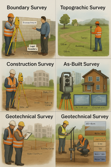
a. Boundary Survey: Defining the Property Lines
A land survey guide for architects wouldn’t be complete without discussing boundary surveys. Boundary surveys are essential for determining the exact location of property lines. This type of survey involves detailed measurements and research of historical records to define the legal boundaries of a property. Architects rely on boundary surveys to ensure their designs respect property limits and avoid legal disputes.
Purpose: A boundary survey determines the precise property lines and defines the true property corners of a parcel of land.
Importance: Boundary surveys are essential for establishing legal property boundaries to prevent disputes and ensure compliance with local zoning regulations. They are typically required during land transfers, property subdivisions, and before construction begins to ensure structures are built within legal limits.
Technology Used: Traditional boundary surveys often involve the use of tape measures, compasses, and theodolites. Modern techniques employ Global Positioning System (GPS) technology and Total Station (TS) for higher accuracy and efficiency.
Process:
1. Research: The surveyor reviews historical records, deeds, and previous surveys to understand the property’s legal description.
3. Analysis: The collected data is analyzed to resolve any discrepancies between historical records and actual measurements.
2. Fieldwork: The surveyor visits the site to measure and mark property lines, using GPS and total stations for precise measurements.
4. Reporting: A detailed map or plat showing the property boundaries, easements, and encroachments is created and provided to the property owner.
b. Topographic Survey: Mapping the Terrain
Topographic surveys are a vital component in land survey guide for architects. These surveys map the natural and man-made features of the land, including elevation changes, trees, buildings, and other structures. Topographic surveys provide a detailed understanding of the terrain, which is crucial for designing structures that interact harmoniously with their environment.
Purpose: A topographic survey maps the physical features and elevations of a land area, providing a detailed representation of the terrain.
Importance: Topographic surveys are critical for site planning and design. They help architects understand the land’s contours, identify natural and man-made features, and plan for drainage, grading, and infrastructure placement.
Technology Used: Advanced tools such as drones, LIDAR (Light Detection and Ranging), DGPS and total stations are commonly used to create detailed topographic maps.
Process:
1. Data Collection: Surveyors use instruments like total stations, DGPS units, and drones to collect elevation data and identify physical features.
2. Data Processing: The collected data is processed using specialized software to generate a detailed topographic map or digital terrain model.
3. Analysis: The topographic map is analyzed to determine how the terrain will impact the design and construction process.
4. Reporting: The final product includes a contour map showing elevation changes, as well as the location of trees, buildings, roads, and other features.
Discover topographic surveying in this article about-topographic-survey
c. Construction Survey: Guiding the Building Process
Construction surveys, also known as stake-out surveys, are used to guide the construction of new structures. This surveys provide the precise locations of proposed structures, ensuring that construction follows the architectural plans accurately. Construction surveys include staking out buildings, roads, and utilities, offering guidance throughout the building process.
Purpose: Construction surveys, also known as stake-out or layout surveys, provide the exact locations of planned structures and guide the construction process.
Applications: These surveys are used throughout the construction phase to ensure buildings, roads, and utilities are built according to design specifications and within legal boundaries.
Technology Used: Total stations, DGPS equipment, and laser scanning are commonly used to stake out precise locations on the construction site.
Process:
1. Preliminary Planning: Surveyors review construction plans and blueprints to understand the project requirements.
2. Staking: Surveyors mark the locations of structures, utilities, and other elements on the ground using stakes, flags, or spray paint.
3. Verification: The staked locations are verified to ensure they align with the design plans and any regulatory requirements.
4. Monitoring: Continuous surveys are conducted during construction to ensure that all elements are built as planned.
d. As-Built Survey: Documenting the Finished Product
As-built surveys, also known as record surveys, are a crucial part of the land survey guide for architects. These surveys document the final positions of structures and improvements on a property. They are essential for verifying that the completed construction matches the approved plans and for future reference in case of modifications or disputes.
Purpose: An as-built survey documents the location of all structures and features on a site after construction is complete.
Applications: These surveys ensure that the completed project matches the design specifications and identify any deviations from the original plans. They are essential for final inspections, project closeout, and future maintenance.
Technology Used: LIDAR, 3D laser scanning, and high-resolution photography are commonly used to create accurate as-built records.
Process:
1. Data Collection: Surveyors use laser scanners, total stations, and other instruments to capture detailed measurements of the completed structures.
2. Data Processing: The collected data is processed to create 3D models or detailed drawings of the as-built conditions.
3. Verification: The as-built data is compared to the original design plans to identify any discrepancies.
4. Reporting: A comprehensive report is created, including detailed drawings, 3D models, and photographs showing the as-built conditions.
If you’re looking to deepen your understanding of As-built Surveys, I encourage you to check out this article www.rvslandsurveyors.com. It could provide some valuable insights for you.
e. Geotechnical Surveys: Understanding the Subsurface
Geotechnical surveys are a critical addition to any land survey guide for architects. These surveys assess the soil, rock, and underground water conditions on a site, providing essential information for foundation design and construction. Geotechnical surveys involve drilling boreholes, taking soil samples, and conducting lab tests to determine the subsurface characteristics.
Purpose: A geotechnical survey assesses the subsurface conditions of a site, providing information about soil, rock, groundwater, and other geologic conditions.
Importance: Geotechnical surveys are crucial for determining the suitability of a site for construction, designing foundations, and identifying potential geologic hazards. They help architects and engineers design safe and stable structures that are suited to the site’s subsurface conditions.
Technology Used: Drilling rigs, boreholes, soil sampling, penetrometers, and geophysical methods such as seismic refraction and resistivity testing.
Process:
- Site Investigation: Geotechnical engineers conduct a preliminary site investigation to identify potential subsurface issues.
- Borehole Drilling: Boreholes are drilled at various locations on the site to collect soil and rock samples from different depths.
- Laboratory Testing: The collected samples are analyzed in a laboratory to determine their physical and chemical properties, such as soil strength, density, permeability, and composition.
- Geophysical Testing: Non-invasive geophysical methods are used to assess subsurface conditions and detect any hidden anomalies or hazards.
- Reporting: A comprehensive geotechnical report is created, detailing the findings and providing recommendations for foundation design, construction methods, and site preparation.
Check out the geotechnical survey details here: www.rvslandsurveyors.com.
3. Advanced Technologies in Land Surveying
The evolution of technology has significantly enhanced the accuracy, efficiency, and scope of land surveys. Modern tools and methods allow surveyors to capture detailed and precise data, transforming how architects plan and execute their projects. Here are some cutting-edge technologies revolutionising the field of land surveying:
a. Drone Surveys
Overview: Drones with high-resolution cameras and LIDAR sensors can quickly capture detailed aerial data. Due to their speed, accessibility, and ability to cover large areas, they have become indispensable tools for surveyors. LIDAR uses laser pulses to measure distances and create high-resolution 3D models of the terrain. It is especially effective in mapping vegetation, water bodies, and complex terrains.
Discover additional information about the application of Drone Surveys on this webpage https://www.rvslandsurveyors.com/?s=Drones
Benefits:
- Rapid Data Collection: Drones can survey large areas in a fraction of the time required by traditional methods.
- Accessibility: They can access hard-to-reach or hazardous areas safely.
- Cost-Effective: Drones reduce the need for extensive manpower and equipment, lowering overall survey costs.
- High Accuracy: Provides precise elevation data and detailed surface characteristics.
- Penetration: Can penetrate vegetation to reveal the ground surface underneath.
- Speed: Quickly collects large amounts of data.
Applications:
- Topographic Surveys: Detailed mapping of terrain and elevation.
- Site Inspections: Monitoring construction progress and site conditions.
- Environmental Surveys: Assessing ecological features and changes.
- Flood Risk Assessment: Identifying flood-prone areas.
- Archaeological Surveys: Discovering hidden structures and features.
Technology Used: High-resolution cameras, LIDAR sensors, DGPS, and specialized software for processing and analysing aerial data.
b. GPS and GNSS (Global Navigation Satellite Systems)
Overview: GPS and GNSS systems provide real-time positioning data with high accuracy. They are essential for boundary determination, construction staking, and large-scale mapping projects.
Benefits:
- High Precision: Accurate positioning and measurements.
- Global Coverage: Can be used anywhere in the world.
- Real-Time Data: Provides instant data for immediate decision-making.
Applications:
- Boundary Surveys: Determining precise property lines.
- Construction Layout: Staking out building locations and infrastructure.
- Geodetic Surveys: Mapping large areas with high precision.
Technology Used: GPS receivers, GNSS systems (such as GLONASS, Galileo), and processing software.
c. Total Stations and Robotic Total Stations
Overview: Total stations combine electronic distance measurement and angular measurement capabilities. Robotic total stations allow for one-person operation and remote control, improving efficiency and accuracy.
Benefits:
- High Accuracy: Precise measurements of distance and angles.
- Efficiency: Robotic stations enable single-person operation, saving time and labor.
- Versatility: Useful for a wide range of survey types.
Applications:
- Construction Surveys: Staking out buildings, roads, and utilities.
- Boundary Surveys: Measuring property lines accurately.
- Topographic Surveys: Creating detailed maps of terrain features.
Technology Used: Electronic distance meters (EDMs), angle measurement sensors, and robotic controls.
d. 360 Virtual Reality Mapping
Overview: 360 Virtual Reality (VR) mapping involves capturing panoramic images and videos to create immersive 3D environments. This technology provides a comprehensive view of a site, allowing stakeholders to explore and analyze it virtually.
Benefits:
- Immersive Experience: Provides a realistic and interactive view of the site.
- Enhanced Communication: Facilitates better understanding and collaboration among stakeholders.
- Remote Access: Allows users to explore the site from anywhere.
Applications:
- Site Inspections: Virtual tours of construction sites.
- Project Presentations: Showcasing designs and progress to clients.
- Historical Preservation: Documenting and preserving historical sites.
Technology Used: 360-degree cameras, VR headsets, and software for stitching and rendering panoramic images.
For more detailed insights, you can refer to the official blog here https://www.rvslandsurveyors.com/vr-for-aec
e. 3D LIDAR Scanning (Matterport)
Overview: 3D LIDAR scanning, including technologies like Matterport, uses laser scanning to capture detailed 3D models of interior and exterior spaces. This technology creates highly accurate and interactive digital twins of real-world environments.
Benefits:
- High Detail: Captures intricate details and textures.
- Interactive Models: Allows users to navigate and interact with the 3D models.
- Time Efficiency: Quickly scans large areas and generates models.
Applications:
- As-Built Surveys: Documenting completed structures.
- Architectural Design: Creating detailed models for design and planning.
- Facility Management: Managing and maintaining buildings.
Technology Used: 3D LIDAR scanners, Matterport cameras, and software for processing and visualizing 3D models.
Discover more about Matterport by exploring their blog at https://matterport.com/blog
f. Building Information Modelling (BIM)
Overview: BIM is a digital representation of the physical and functional characteristics of a building. It provides a comprehensive database of information that can be used throughout the building’s lifecycle, from design and construction to operation and maintenance.
Benefits:
- Integrated Data: Combines all aspects of a project into a single, cohesive model.
- Collaboration: Enhances collaboration among architects, engineers, and contractors.
- Visualization: Provides 3D visualizations that help in design and planning.
- Efficiency: Streamlines project management and reduces errors.
Applications:
- Design Coordination: Integrating architectural, structural, and MEP (Mechanical, Electrical, Plumbing) designs.
- Construction Management: Planning and monitoring construction activities.
- Facility Management: Managing building operations and maintenance.
Technology Used: BIM software such as Autodesk Revit, ArchiCAD, and Navisworks.
Stay updated with BIM technology trends by visiting their article land-surveying-in-bim-aec-industry
g. Geographic Information System (GIS)
Overview: GIS is a system designed to capture, store, manipulate, analyze, manage, and present spatial or geographic data. It integrates hardware, software, and data for capturing and displaying all forms of geographically referenced information.
Benefits:
- Spatial Analysis: Allows for complex spatial analysis and modeling.
- Data Integration: Combines various types of data for comprehensive analysis.
- Decision Support: Provides valuable insights for decision-making and planning.
- Visualization: Creates detailed maps and visualizations.
Applications:
- Site Selection: Analysing geographic data to select optimal sites for development.
- Environmental Impact Assessment: Assessing the environmental impacts of projects.
- Urban Planning: Supporting urban planning and development projects.
Technology Used: GIS software such as ESRI ArcGIS, QGIS, and MapInfo.

Practical Tips for Architects
Integrating advanced survey data into architectural projects requires careful consideration and collaboration. Here are some practical tips:
- Collaborate with Surveyors: Establish a strong working relationship with professional surveyors to ensure accurate and timely data.
- Understand the Data: Familiarize yourself with the types of survey data and their applications to make informed design decisions.
- Leverage Technology: Utilize software tools that integrate survey data with architectural design, such as GIS (Geographic Information Systems) and BIM (Building Information Modelling).
- Verify Data Accuracy: Double-check survey data for accuracy before incorporating it into your designs to avoid costly errors.
- Stay Updated: Keep abreast of the latest advancements in surveying technology to enhance your project’s efficiency and precision.
4. Case Studies: Successful Integration of Survey Data
Examining real-world examples can provide valuable insights into the practical application of land surveys in architectural projects.
a. Urban Redevelopment Project
Scenario: An architect is tasked with designing a mixed-use development in a dense urban area.
Challenges: Limited space, existing infrastructure, and regulatory constraints.
Solution: Conducting a detailed topographic and boundary survey to understand the site’s constraints and opportunities. Integrating the data into BIM software allows for efficient space utilization and compliance with regulations.
Outcome: The project is completed on time and within budget, with optimal use of space and minimal disruption to the surrounding area.
b. Rural Infrastructure Development
Scenario: Designing a new transportation network in a rural area.
Challenges: Varied terrain, environmental concerns, and community impact.
Solution: Utilizing drone surveys and LIDAR technology to map the terrain accurately. Geodetic surveys ensure the infrastructure aligns with regional planning goals.
Outcome: The infrastructure project is executed with minimal environmental impact, improved connectivity, and community satisfaction.
Conclusion
Land surveys and the technologies that support them are indispensable tools for architects. They provide the critical data needed to design, plan, and execute projects with precision and efficiency. By understanding and leveraging these surveys and technologies, architects can enhance their projects’ accuracy, sustainability, and overall success.
Feel free to leave a comment below if you have any questions or experiences to share about land surveying and architectural projects. Your insights are valuable to the community!.
By mastering the knowledge and application of land surveys and advanced technologies, architects can significantly enhance their project’s success, ensuring that every design is grounded in precise and reliable data.