India’s rapid urbanization and population growth have made infrastructure development a national priority. At the core of this transformation lies the AEC (Architecture, Engineering, and Construction) industry—a multifaceted sector that integrates design, technology, and execution to shape the nation’s built environment. The integration of Virtual Reality (VR) further accelerates this transformation, offering immersive, real-time experiences that revolutionize the way AEC professionals plan and deliver infrastructure.
What is AEC?
AEC stands for Architecture, Engineering, and Construction — a collaborative industry responsible for designing, constructing, and maintaining the physical infrastructure that supports modern life, including:
- Buildings: Residential, commercial, and institutional
- Transportation: Roads, bridges, metros, airports
- Utilities: Water supply, power grids, drainage systems
Each discipline in AEC plays a distinct but interdependent role:
- Architects envision and design structures
- Engineers ensure feasibility and safety
- Construction teams execute the plans on-site
Key Components of the AEC Sector
1. Architecture
Architects shape functionality and aesthetics using tools like AutoCAD and Revit. Sustainable and user-centric designs are central to their practice.
2. Engineering
Engineers ensure infrastructure is viable and efficient:
- Civil: Foundations, roads, and drainage
- Structural: High-rise and complex buildings
- MEP: Utilities and mechanical systems
3. Construction
This is the implementation phase, involving labor, material logistics, and technology tools like BIM and digital project management platforms.
The Role of AEC in India’s Infrastructure Boom
1. Government Initiatives Fueling Growth
Flagship schemes are driving infrastructure development:
2. Urbanisation and Real Estate
By 2031, India will house over 600 million urban residents. AEC must deliver:
- High-density, vertical housing
- Transit-oriented development
- IGBC-certified green buildings
Virtual Reality in AEC: Transforming Design and Construction
Virtual Reality (VR) introduces immersive 3D simulations that empower stakeholders to experience, evaluate, and modify infrastructure designs in real time.
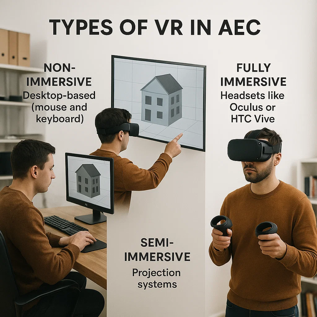
Types of VR in AEC
- Non-Immersive: Desktop-based (mouse and keyboard)
- Semi-Immersive: Projection systems
- Fully Immersive: Headsets like Oculus or HTC Vive
Key Benefits of VR in AEC
- Enhanced Visualisation: View unbuilt structures from inside
- Early Clash Detection: Spot issues before construction
- Client Communication: Virtual walkthroughs clarify design intent
- Remote Teamwork: Collaborate globally
- Mockup Reduction: Save cost on physical prototypes
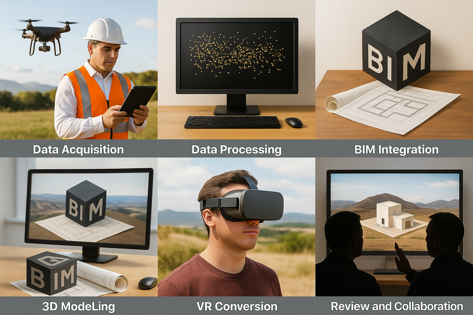
Implementation Workflow: From Raw Data to Immersive Visualisation
A structured process to convert ground data into high-fidelity VR visualisations:
- Data Acquisition: High-resolution topographic, contour, and boundary data is captured using drones, LiDAR, and photogrammetry.
- Data Processing: Point clouds, orthophotos, and digital elevation models (DEMs) are processed using specialised GIS and CAD software.
- 3D Modelling: Terrain and structural elements are modelled in 3D using tools like AutoCAD Civil 3D, Revit, and SketchUp.
- BIM Integration: Site models are aligned with building elements using BIM workflows.
- VR Conversion: The complete model is exported to engines like Unity or Unreal Engine to create an interactive VR environment.
- Review and Collaboration: Clients and architects can explore the site in VR, provide feedback, and finalise layouts interactively.
Real-World Applications of VR in AEC
1. Design and Conceptualisation
- Interactive material and spatial previews
- Lighting and acoustic simulations
2. Construction Planning
- 4D sequencing and virtual logistics
- Safety testing for equipment and personnel
3. Sales and Marketing
- Virtual tours for real estate buyers
- Customisation in VR environments
RVS Land Surveyors have started integrating immersive VR walkthroughs with topographic and contour survey data to give developers and architects a realistic understanding of land features before planning or construction. Our work helps identify terrain constraints early and provides real-time geospatial feedback in 3D.
Technologies Empowering VR in AEC
- Unreal Engine & Unity: Game engines for real-time rendering
- Autodesk Revit + Enscape: BIM-integrated visualisation
- Matterport: Digital twins for immersive site capture
RVS Survey Integration: RVS Land Surveyors use drone surveys, photogrammetry, and LiDAR scans, converted into VR environments for detailed project previews.
VR and BIM Integration
Merging VR with Building Information Modelling (BIM) enhances design workflows:
- Navigate BIM models in immersive 3D
- Simulate construction sequences
- Conduct clash detection and material testing
RVS Land Surveyors enhance BIM inputs by providing georeferenced terrain models and digital elevation data, helping AEC firms align BIM models accurately within real-world contexts.
Future Trends in VR for AEC
1. AI-Driven VR Simulations
Generative AI can create optimised design environments for cost, energy, and structure.
2. Cloud Collaboration
VR tools hosted on cloud platforms allow distributed teams to co-review designs in real-time.
3. IoT Integration
Overlaying smart sensor data in VR environments enables live facility monitoring and predictive maintenance.
4. Haptic and Spatial Enhancements
Advanced VR now includes:
- Haptic feedback for touch simulation: This technology allows users to feel textures, pressure, and movement in virtual spaces, making interactions more intuitive and realistic.
- Spatial audio for realistic soundscapes: Directional sound enhances immersion by replicating how sounds behave in physical environments, improving perception of distance, movement, and ambiance.
Challenges and Solutions
- Cost: Offset via phased adoption and cloud tools
- Learning Curve: Resolved with training
- Data Complexity: Addressed by using interoperable BIM formats
- Hardware Requirements: Cloud VR reduces reliance on high-end PCs
Opportunities in AEC with VR Expertise
As projects become more technology-driven, new roles are emerging:
- VR/BIM Specialist
- Digital Twin Coordinator
- Immersive UX Designer
- Smart Infrastructure Analyst
RVS Land Surveyors are expanding expertise by combining geospatial data with immersive VR to support AEC firms, positioning themselves as valuable partners in land-based digital design solutions.
Conclusion
The fusion of AEC and VR marks a turning point in India’s infrastructure journey. Together, they create smarter cities, sustainable buildings, and efficient public works. As digital tools become mainstream, VR-enabled AEC will define the nation’s infrastructure narrative in the decades to come. RVS Land Surveyors, by combining land surveying with immersive technologies like VR, play a pivotal role in enhancing project feasibility, reducing errors, and enabling smart infrastructure planning across India.
Ready to take your projects into the future? Partner with RVS Land Surveyors and explore how VR can transform your next infrastructure venture. Contact us today to get started.